



Clime
The climate in the municipality is moderate-continental, with Mediterranean influence through the canyon Grlo to the southwest of the Little Prespa Lake and through the mountain pass Prevtis to the southwest of Mala Prespa. It conditions warm summers with cool nights and mild winters. The average annual relative humidity is 64%.
Most of this is a valley under the water of Lake Prespa, which to some extent appears as a climate modifier of its surroundings. The lake is located at an altitude of 850 m, and is a thermostat for the surrounding air, especially the air temperature in the winter months in December and January. The average annual temperature is 10.2 ° C, with the warmest month of July with an average monthly temperature of 21 ° C, the minimum value of 0.3 ° C in January. The Prespa valley is characterized by long-term solar radiation and the average annual amount is 1,400 to 2,600 hours. Fog in the Prespa area is rare, mainly due to frequent ventilation and the presence of large lake water areas.
The hydrological and meteorological surveillance monitoring was conducted in accordance with the Law on Hydro-meteorological Affairs, the Law on Waters and the program for protection of Lakes Ohrid, Prespa and Dojran.
The meteorological / climatological network consists of one climatological station (Resen), one meteorological station (Pretor) and seven measuring stations for measuring the intensity of precipitation. The climatological station in Resen was established in 1947 as a station for measuring the intensity of precipitation and functioned as such between 1980 and 1993. The Pretor meteorological station was established in 1980 as a heavy rain prevention site, employing experts to monitor meteorological parameters. Seven stations for measuring the intensity of precipitation are distributed as follows: five of them on the shores of Lake Prespa – Stenje, Carev Dvor, Perovo, Asamati and Nakolec and two at higher altitudes (Izbista and Brajcino). These measuring stations register the state of the pluviographic regime on the shores of Lake Prespa as well as on the surface of the lake itself. No information is available on the higher parts of the watershed.
Climatological parameters – Measuring station„Pretor“(period 1991-2010)
| Month | January | February | March | April | May | June | July | August | September | Octomber | November | December | Year |
|---|---|---|---|---|---|---|---|---|---|---|---|---|---|
| Temperature [C] | 1,8 | 2,4 | 5,5 | 9,6 | 14,7 | 18,7 | 21,3 | 21,1 | 16,5 | 12,3 | 7,4 | 3,1 | 11,2 |
| Precipitation [mm] | 40,0 | 52,2 | 41,0 | 52,9 | 40,1 | 26,6 | 24,7 | 23,4 | 57,1 | 69,0 | 67,8 | 75,5 | 570,4 |
| Humidity H [%] | 72 | 67 | 63 | 63 | 64 | 62 | 57 | 56 | 63 | 69 | 70 | 73 | 65 |
| Insolation SI [hours] | 112,2 | 130,1 | 176,6 | 173,3 | 329,6 | 275,2 | 321,4 | 309,5 | 221,9 | 174,2 | 118,2 | 85,5 | 2427,6 |
| Winds [m/s] | 1,4 | 1,7 | 1,9 | 1,7 | 1,2 | 1,3 | 1,4 | 1,4 | 1,6 | 1,3 | 1,4 | 85,5 | 1,5 |
| Drought index - DI | 40,8 | 50,5 | 31,7 | 32,5 | 19,5 | 11,1 | 9,5 | 9,0 | 25,9 | 37,2 | 46,8 | 69,1 | 26,9 |
Precipitation in the Prespa region
| Month | January | February | March | April | May | June | July | August | September | Octomber | November | December | Year |
|---|---|---|---|---|---|---|---|---|---|---|---|---|---|
| Asamati | 57,14 | 60,91 | 51,36 | 47,60 | 61,24 | 33,07 | 30,96 | 28,99 | 41,08 | 67,38 | 91,62 | 63,74 | 625,01 |
| Stenje | 89,45 | 88,02 | 79,86 | 75,97 | 67,81 | 36,24 | 34,88 | 33,59 | 58,74 | 102,85 | 126,64 | 113,41 | 873,68 |
| Izbishta | 83,63 | 91,14 | 69,46 | 63,38 | 69,16 | 41,75 | 32,29 | 33,23 | 52,00 | 88,89 | 112,55 | 95,91 | 821,89 |
| C. Dvor | 61,03 | 54,53 | 49,97 | 44,09 | 50,40 | 30,55 | 28,84 | 27,79 | 45,05 | 65,05 | 85,87 | 73,80 | 611,51 |
| Nakolec | 51,77 | 57,83 | 44,95 | 42,00 | 54,06 | 34,06 | 25,56 | 34,45 | 44,13 | 60,10 | 73,34 | 60,02 | 571,77 |
| Brajchino | 59,23 | 67,06 | 51,68 | 57,30 | 68,63 | 41,79 | 41,14 | 34,67 | 51,81 | 71,03 | 84,19 | 71,94 | 684,30 |
| Resen | 71,54 | 73,52 | 55,57 | 50,83 | 67,09 | 36,79 | 26,33 | 25,69 | 47,33 | 72,96 | 104,61 | 75,57 | 707,82 |
| Pretor | 39,99 | 52,18 | 41,04 | 52,94 | 40,11 | 26,58 | 25,96 | 24,66 | 57,14 | 72,60 | 67,84 | 75,52 | 570,37 |
| Total | 64,2 | 68,1 | 55,5 | 54,3 | 59,8 | 35,1 | 30,7 | 30,4 | 49,7 | 75,1 | 93,3 | 78,7 | 683,3 |
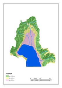 Izohiet map
The specific orographic characteristics that influence dynamic climatic factors, together with the influence of geographical and local factors, create three different climatic types throughout the basin: hot and cold sub-Mediterranean (850 ÷ 1 100 m asl); sub-mountainous and mountainous sub-Mediterranean (1,100 ÷ 1,650 m asl) and sub-alpine and alpine climate zone (1,650 ÷ 2,420 m asl). The annual average temperature is relatively low (T = 9.6 0C; Tmax = 37.0 0C – 06.07.1988; Tmin = -26.5 0C – 14.01.1968). The specific local warm continental climate is a result of the relief, altitude, fluctuation of the water level of Lake Prespa and the weak influence of the Mediterranean climate. The Big and Small Prespa Lakes are equipped with a total of 13 stations for measuring the intensity of precipitation (7 in Macedonia) and it must be mentioned that most of them are in operation today. Monthly rainfall is usually reached in November, while in summer between June and July their intensity is lowest. From September to November, the intensity of precipitation increases significantly, while in the period from January to May they oscillate around elevated levels of intensity. Generally, the eastern and southern measuring stations show values between 600 and 700 mm / year. On the other hand, in the north and in the west the precipitations are present with slightly higher intensity 700 and 930 mm / year. Given that there is no measuring station in the high mountainous parts, according to the isohyetic maps created by AHMA, the annual rainfall intensity in these regions reaches 1,050 mm.
The values in the table show the precipitation only in the lower parts of the Prespa region. Considering that the precipitation in the higher mountainous parts is higher, the values are defined, based on isohygetic maps.
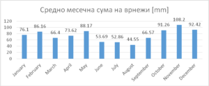
Average monthly rainfall in the Prespa region
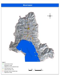 Climatological and hydrological stations in the Prespa region
The hydrological monitoring system consists of the operation of hydrological stations on rivers and lakes. Lake stations whose task is to measure the level and temperature of water were established in 1935 (Stenje), 1948 (Asamati) and 1954 (Nakolec). Each of them is equipped with devices for measuring the water level. External collaborators are responsible for monitoring the water temperature level in the lake. Numerous interruptions in work and discontinuity of monitoring occurred at these measuring stations, especially during World War II. The ASAMATI hydrological station stopped operating shortly after 1990. The river stations are located on Golema Reka (2) and Brajchinska Reka (1). The hydrological station “Resen” started operating in 1947 and since then has been operating with several intermediate interruptions as a result of major changes in the riverbed. Providing unused hydrological information, this station ceased operations in the late 1980s. The hydrological station “Leva Reka” was opened in 1986 on Leva Reka (a tributary in the upper course of Golema Reka) as an alternative to the hydrological station “Resen”. Simultaneously, the flow measurements were performed at both sites. The station is equipped only with the above-mentioned devices and an external collaborator for daily water level measurements. The hydrological station “Brajcino” started operating in 1964 in the village of Brajcino and operates continuously to this day. The distribution of this station was made in 1986, moving upstream by installing an automatic instrument for registering the water level, called “limnograph”.
The water level in Lake Prespa shows significant oscillations. The highest value was reached during the flood in 1963 with 853.4 m asl, which corresponds to a lake with an area of about 280 km². The water level has since dropped to approximately 844.65 m asl with the largest decline between 1986 and 1991. The last lowest detected values for the water level were observed in 2002 with exactly 844.5 m above sea level. Lake Ohrid flows into the river Crn Drim, which further flows into the Adriatic Sea. Since 1962, the water flowing from Lake Ohrid has been controlled by the local self-government of the city of Struga by installing a dam. The operation of this structure is regulated by the needs of the hydropower plants and the need to maintain the water level in the lake at an acceptable optimal level. According to continuous measurements (1982 ÷ 2001), the average lake runoff is Q = 21 m³ / s.
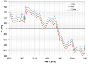 The water level in the Great Prespa Lake
Precipitation results according to the runoff model for the period of 54 years starting from 1951 to 2004 are summarized in the table for the four subsurface areas. The specific discharges shown reflect the hydrographic characteristics of the investigated subsurface areas. The results for the Southern Greek subordination are confirmed by the results of the Greek model. The connection between the outflows of the floodplains is also confirmed by the “CORINE Land Use Classification” which was conducted at the University of Skopje. From this analysis it can be concluded that the thickening of the forest cover reduces the specific leaks, if the other parameters are constant. This is confirmed by general experience.
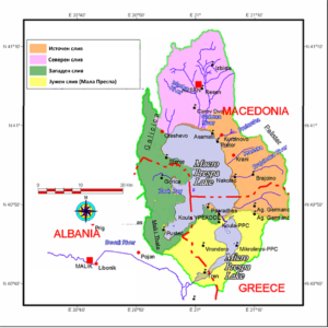
| Sub-basin | Area [km²] | Average annual expiration [m³/s] | Average annual specific expiration [l/s/km²] |
|---|---|---|---|
| Eastern | 270,9 | 3,6 | 13,4 |
| Northern | 320,0 | 4,6 | 14,2 |
| Western | 247,6 | 2,4 | 9,7 |
| Southern | 218,9 | 2,5 | 11,4 |