



Hydrology and Hydrography
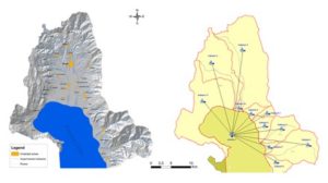
Lake Prespa with its tributaries is the main hydrographic object on the territory of Resen. The main tributaries of the Macedonian part of Lake Prespa are: Brajcinska River, Kranska River, Golema River, East River and Kurbinska River. From a hydrogeological point of view, there are only a few intermittent watercourses, but their flowing power is significant and several times in history they have caused great damage during floods. Each of these tributaries flows into Lake Prespa and are mountain streams with large height differences from the source to the estuary (> 1000 m).
In the catchment area of Lake Prespa, two springs with a flow of over 30 l / s have been registered near the village of Krusje, one spring with a flow of 11 ÷ 30 l / s and a number of springs with a flow of less than 1 l / s.
The static groundwater level in some areas is different and ranges from 1.0 m. in some parts, up to less than 6.0 m in other parts. Surface – untreated water, which is present in many places during heavy rains, along the streets and other urban areas, raises the groundwater level.
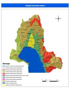
Prespa valley as part of the western – Macedonian hydrogeological region is characterized by the presence of rocks with different hydrogeological characteristics and types of porosity (fractured / broken, closed, karst and karst-fracture type protruding) as well as the occurrence of mineral and thermo-mineral groundwater .
The cracked type of outcrop covers the high mountainous areas where there is medium and low water permeability, with a yield of about 0.1 – 5.0 l / s.
Compact type of outcrop: The tectonic depression is filled with sediments from the Pleocene and Quaternary where there are well and artesian (subartesian) groundwaters. The substrate consists of Paleozoic shale, granite and Mesozoic limestone. The well type of aquifer is characterized by widespread use and has been detected at several sites (Lavci, Bolno, G. Dupeni, Asamati, C. Dvor, etc.). Quaternary sediments have different origins, lithological composition and hydrogeological functions (alluvial, proluvial, diluvial, eluvial, organic-marshy, etc.).
Karst type of outcrop occurs in Paleozoic, Mesozoic and Tertiary carbonate rocks on Mountain Galicica. The largest source of limestone in Macedonia is St. Naum, with a variable capacity (Cvijic, J., 1911) of 2 – 40 m3 / s. A small part of limestone springs exist in the eastern part of Galicica (Prespa). There are two limestone springs on the mountain Bigla on the locality “Krusje” with a capacity of (35 ÷ 160 l / s).
The Prespa sub-basin belongs to the Crn Drim river basin and is part of the Drim river basin. Lakes Ohrid and Prespa belong to the group of Desaret lakes that originate from the geotectonic depression that occurred 2 to 3 million years ago in the western parts of Mount Dinaridi. There are only a few lakes of similar origin in the world.
Due to the limestone substrate, a large amount of water from Lake Prespa enters the soil from the bottom and passing through a network of underground cracks supplies water to the springs located on the Ohrid coast.
Lake Prespa is located at about 850 meters above sea level which can vary from 843.55 meters (October 2003) to 851.77 meters (June 1963). It is composed of two interconnected lakes: the Small Prespa Lake and the Big Prespa Lake. The watershed is divided between: Macedonia, Greece and Albania. Lake Prespa forms an indoor basin surrounded by high mountains. To the west – the mountain Galicica (2 256 m), to the north – Plakenska Mountain (1,935 m), the mountain Bigla (1 656 m) to the northeast, to the east Baba Planina (2,420 m), the mountain Triklarion to the southeast (1,749 m) ), south of Suva Gora (1,480 m) and southwest with Mali and Tate (2,288 m).
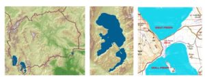
The Big and the Small Prespa Lakes are separated by a cover. Between 1962 and 1975, the two lakes were connected and the water levels adjusted.
The total area of the region (taking into account the differences in the measurements – difference in scale, differences in the defined boundary of the limestone area) is between 1 368 ÷ 1 386 km2.
Due to fluctuations in the water level, the area of the lake surface varies from 306 ÷ 324 km2.
The area of the Great Prespa Lake ranges from 259.4 ÷ 280.0 km2 (MKD – 68.1%, ALB – 17.9%, GR – 14.0%). The area of the Small Prespa Lake ranges from 44.4 ÷ 47.4 km2 (MKD – 0%, ALB – 10%, GR – 90%).
The total area of the watershed is about 1052.41 km2 (MKD – 583.00, ALB – 214.09, GR – 255.32).
| Area (km2) | Basin Area (km2) | Hmin (м.н.в.) | Hmax (м.н.в.) | Hav (м.н.в.) | Slope (%) | Big Lake (km2) | Small Lake (km2) |
|
|---|---|---|---|---|---|---|---|---|
| Macedonia | 761,00 | 593,00 | 844 | 2 420 | 1 118,37 | 21,37 | 178,0 | 0,0 |
| Albania | 261,19 | 214,09 | 844 | 2 275 | 1 207,41 | 26,23 | 42,7 | 4,4 |
| Greece | 341,52 | 255,32 | 844 | 2 161 | 1 132,60 | 24,41 | 42,4 | 43,8 |
| Total: | 1 363,71 | 1 052,41 | 263,1 | 48,2 |
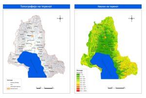
The area covered in the Plan 2010 is the Macedonian part of the Great Prespa Lake, classified as hilly and hilly-mountainous landscape. It can be divided into the Prespa Valley and the surrounding mountains – Baba, Ilinska and Galicica. The hilly and hilly-mountainous part of this region is characterized by high slope (greater than 32%).
Specific orographic conditions, together with geographical and local factors, influence dynamic climatic factors, creating three different climatic types throughout the basin: warm and cold continental; sub-mountainous and mountainous sub-Mediterranean and subalpine and alpine climatic zone. The annual average temperature is relatively low, but still very suitable for the development of fruit growing, especially for growing apples. The specific local warm continental climate is a result of the relief, the altitude, the fluctuation of the water level of Lake Prespa and the weak influence of the Mediterranean climate.